For forest insurers

From months to days:
faster storm claims with
AI-powered satellite damage assessment

  • Priority zones & damage maps, delivered in a few days after the event
  • Cost-effective, objective, at scale
Goodforest app — damage heatmap

Forest damage is hard to localise, harder to measure and every delay has a cost.

You don't know where to look first

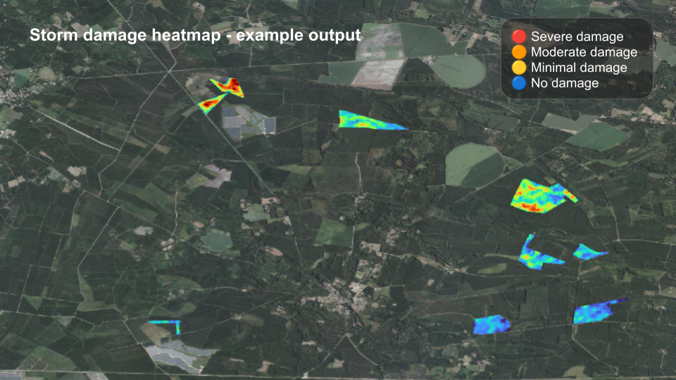
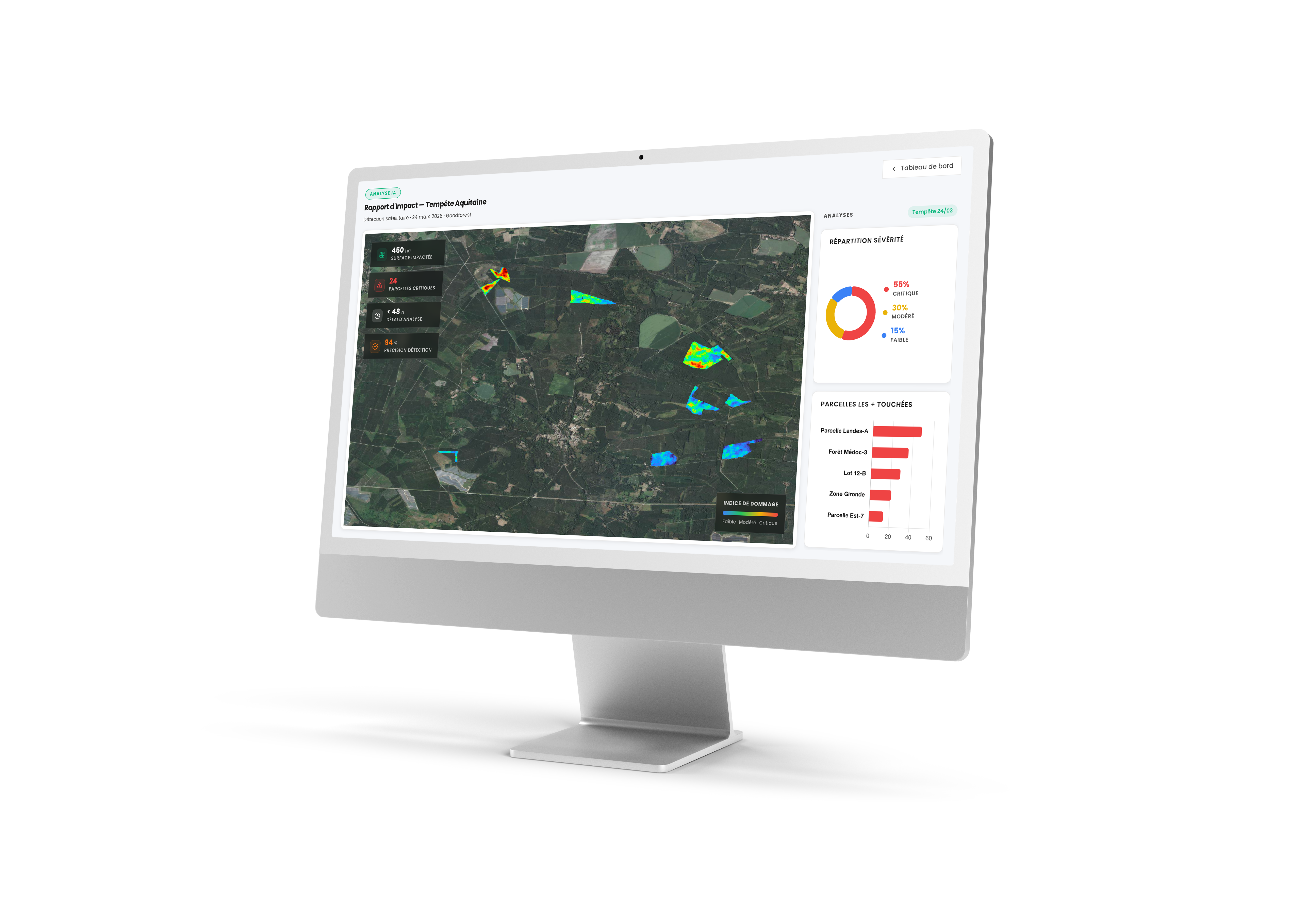
After Storm Vaia (Italy, 2018), which devastated over 40,000 hectares of Alpine forest across hundreds of municipalities, insurers faced a flood of simultaneous claims — with no fast way to know where the damage was worst. Experts get mobilized where damage is limited — while the critical zones wait.

The clock is ticking on your timber

Fast-degrading species like spruce and maritime pine need rapid assessment. Post-Ciaran (France, 2023), some expertises took up to 6 months. The longer the wait, the harder it is to salvage and sell the timber — and to close the claim cleanly.

When access is impossible, data becomes critical

Ground conditions can make expert deployment dangerous or impossible for days. Drone surveys face the same constraints — weather windows, certified pilots, flight authorizations. Satellite assessment delivers precise damage rates and affected zones, regardless of conditions on the ground

Disputed claims need objective ground truth

When damage figures are contested, a satellite-based assessment from a trusted third party gives everyone — insurer and owner — a shared, independent reference point.

Satellite and AI, delivering forest damage assessment at scale.

01

Define your perimeter

Submit the affected area via our platform. No technical setup required.

02

Satellite captures, AI processes

We turn raw imagery into precise damage data — automatically, at scale.

03

You get actionable results

A damage heatmap and priority zones — ready to use in your claims workflow.

Storm damage heatmap — example output showing severity zones across a forest area

Multi-source satellite data

Radar (Sentinel-1) + multispectral (Sentinel-2) + very high resolution imagery.

Deep learning models

State-of-the-art AI architecture, built for forest damage assessment.

Trained on forest data

Models trained on thousands of hectares of documented European storm damage.

Two services, one platform
built for storm events.

Self-service

Damage Heatmap

Get visibility fast

Identify the most affected zones across your insured portfolio. Prioritize expert deployment with data.

From €10/ha

Get started
On demand

Full Damage Assessment

Precise damage rates by plot

Detailed damage zones and rates — ready to use in your claims documentation. Adapts to your existing workflow and report format.

API Integration available

Custom pricing

Talk to our team

Deployed on real events across
Europe and beyond.

Storm Nils · France 2026 Storm Goretti · France 2026 Wildfire events · Europe & Australia

"We were able to reassure our clients quickly — they knew where they stood before the expert even arrived."

Claims manager, French insurer

"We sent experts to the right places first. The most critical parcels got assessed faster, which made a real difference for salvage operations."

Claims manager, large forestry portfolio

"On the ground, we went straight to the most damaged areas of the parcel. No time wasted."

Forest manager, France

"It gave us an objective basis for the claims conversation — and helped avoid unnecessary counter-expertise."

Underwriter, French insurer

Common questions.

How long after the event can you deliver results?

Delivery time depends on satellite revisit frequency and cloud cover over the affected area. Results are typically available within a few weeks post-event — significantly faster than traditional on-site expert assessment. We'll give you an honest timeline estimate as soon as you submit your perimeter.

What is the spatial resolution of your analysis?

Our analysis reaches a granularity of 100 m², allowing precise plot-level damage mapping across your entire insured portfolio.

Is it compatible with my existing claims workflow?

Yes. We adapt to your existing workflow and report format. API integration is available for teams who want to connect Goodforest directly to their claims management systems. Contact us to discuss your setup.

Does it work for all forest types?

Yes — our models work regardless of tree species or forest composition. Whether your portfolio includes coniferous, deciduous, or mixed stands, the analysis applies.

Ready to see your forests clearly after the next event?

Start a heatmap analysis

Self-service. Submit your perimeter, get your damage heatmap.

Get your damage map — from €10/ha

Talk to our team

For full damage assessment, large portfolios, or any question.

Book a call →